Jordan — the River of the Rising Sun
Jesus = Helios, the Sun of God
The Jordan: The River of the Rising Sun
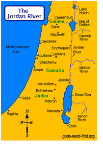
Jesus earned his title of the Christ (the anointed one) when he was christened by John the Baptist in the Jordan River, the only river that can be located from any point in the Holy Land by walking “toward the rising of the sun” (Joshua 12:1). As the map shows, the Jordan river flows from north to south along its entire length and was thus the eastern boundary of Galilee, Samaria, and Judea, the lands where Jesus practiced his ministry. The river was given that title as long as a person was standing anywhere on its West bank because the East is the direction from where the sun rises.
The River Jordan is derived from the Hebrew word yar-dane, meaning “descender.” The “Descender” is a very appropriate name for the river because it flows in a virtually perfect north-south line on a map from its source near Mount Hermon (about 10 miles north of Lake Huleh) to its terminus at the Dead Sea, the lowest point of any lake on earth.
The elevation of the river drops virtually 2,368 feet from its source to where the river flows into the great salt sea. The length of its meanders over the same two points measures approximately 318 kilometers, over twice its direct distance. Coincidentally, these two modern measures correspond to the gematria value of Jesus Christ (2368) and Helios (318), the sun.